








Geospatial AI Development Company

Geospatial AI Development Company

Comfygen builds custom geospatial AI platforms: software that reads satellite imagery, GIS layers, and sensor data, then detects change and predicts risk on its own. Hire our developers to take a geospatial idea from data pipeline to production dashboard, backed by 7+ years of software delivery across 550+ projects.

 Industry Experience
Since 2019
Industry Experience
Happy Clients
400+
Happy Clients
Countries Served
30+
Countries Served
Projects Delivered
550+
Projects Delivered

Geospatial AI Development Services

Six services Comfygen's developers build for clients who need a geospatial AI platform without hiring and managing an in-house team.

Custom GIS applications, WebGIS platforms, and spatial databases built on PostGIS, GeoServer, and the Esri and QGIS ecosystem.

services background

GIS Software Development

Custom GIS applications, WebGIS platforms, and spatial databases built on PostGIS, GeoServer, and the Esri and QGIS ecosystem.

Satellite Imagery Analysis

Platforms that ingest Sentinel, Landsat, and SAR data and turn it into land cover maps, change detection, and anomaly alerts.

Remote Sensing App Development

Machine learning models trained on satellite and aerial imagery for object detection, classification, and monitoring at scale.

Wildfire Management Software

Fire risk scoring, spread prediction, and situational awareness tools built on NASA FIRMS data and live weather feeds.

Forest Monitoring & Carbon MRV

Digital MRV platforms for forest carbon projects, biomass estimation, and deforestation alerts aligned with Verra and Gold Standard.

EUDR Compliance Software

Due diligence platforms that trace a commodity to its exact plot and flag deforestation risk under the EU Deforestation Regulation.

What is geospatial AI development?

What is geospatial AI development?

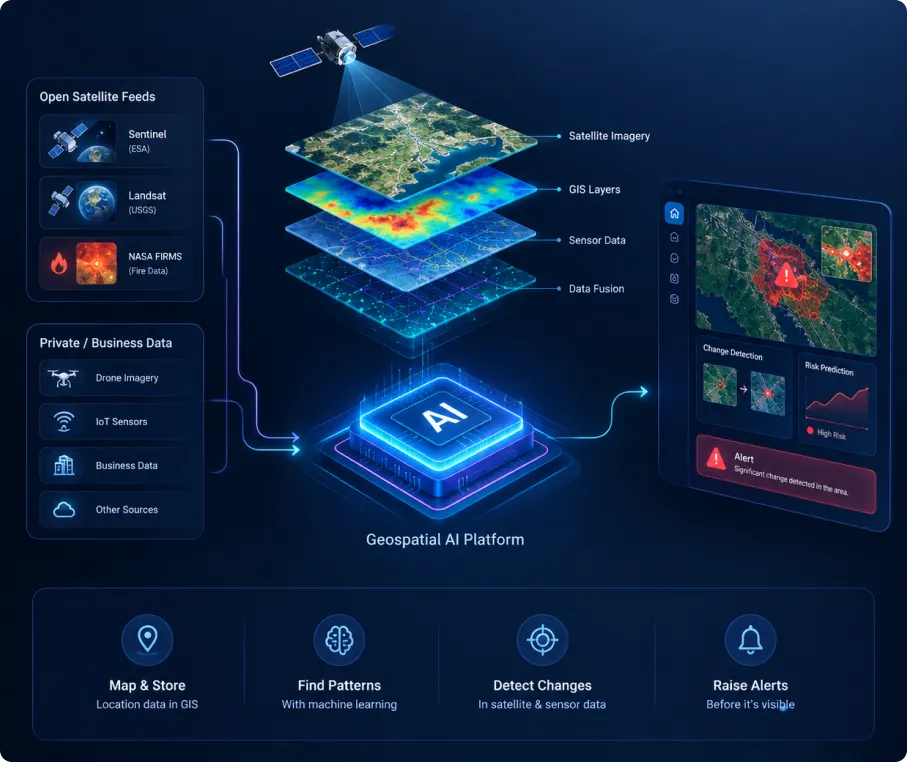
Geospatial AI combines two fields: Geographic Information Systems, which store and map location data, and machine learning, which finds patterns in it. Put together, a geospatial AI platform can read satellite images, flag changes on the ground, and raise an alert before a person would ever spot it by eye.

Comfygen's developers build this kind of system for clients who don't have a geospatial team in-house yet, starting from open satellite feeds like Sentinel, Landsat, and NASA FIRMS, then adding private sensor or business data on top.

Industries We Build Geospatial AI For

Agriculture & precision farming

Crop health maps, yield prediction, irrigation planning

Insurance & climate risk

Wildfire and flood risk scoring for underwriting

Forestry & conservation

Deforestation alerts, biomass and carbon estimation

Government & urban planning

Land use tracking, infrastructure and disaster response

Utilities & energy

Vegetation management, wildfire ignition risk along grid lines

Supply chain & compliance

EUDR due diligence, commodity geolocation and traceability

What a Geospatial AI Platform Costs to Build

Cost depends on data volume, how many models the platform runs, and how deep the integrations go. These are planning ranges; ask Comfygen for a fixed quote once scope is set.

What a Geospatial AI Platform Costs to Build

GIS mapping platform (MVP)

Typical Cost:$15,000 – $40,000
Typical Timeline:8–12 weeks

Satellite imagery analysis tool

Typical Cost:$30,000 – $80,000
Typical Timeline:12–20 weeks

Wildfire risk & prediction platform

Typical Cost:$40,000 – $100,000+
Typical Timeline:16–24 weeks

Forest carbon MRV platform

Typical Cost:$35,000 – $90,000
Typical Timeline:14–22 weeks

EUDR compliance platform

Typical Cost:$25,000 – $60,000
Typical Timeline:10–16 weeks

Comfygen's Geospatial AI Development Process

Seven steps from first call to a platform that keeps running after launch.

Discovery

Comfygen's team maps your data sources, compliance needs, and the decision the platform has to support, before any design work starts.

Data & Architecture

Satellite, sensor, and business data get mapped into a spatial database, with a pipeline that runs on a schedule or in real time.

Model Development

Machine learning models get trained and tested against your actual imagery and ground truth, not a generic public dataset.

Integration & Testing

The platform connects to your existing systems or compliance workflow, and gets tested against real-world edge cases.

Deployment & Support

The system goes live with monitoring in place. Comfygen's team stays on for fixes, retraining, and new data sources as they come up.

Performance Monitoring & Optimization

Model accuracy and pipeline health get checked after launch, with retraining when new imagery or changing ground conditions shift the results.

Scalability & Future Enhancements

New regions, data sources, and services get added as the platform grows, including a path into compliance reporting where it applies.

Discovery

Comfygen's team maps your data sources, compliance needs, and the decision the platform has to support, before any design work starts.

Geospatial AI Technology Stack

PostGISPostGIS
GeoServerGeoServer
GDALGDAL
QGISQGIS
ArcGISArcGIS
PythonPython
PyTorchPyTorch
TensorFlowTensorFlow
Google Earth EngineGoogle Earth Engine
Sentinel Hub APISentinel Hub API
NASA FIRMS APINASA FIRMS API
AWS CloudAWS Cloud

Why hire Comfygen for geospatial AI development

Comfygen brings seven years of software delivery and an honest account of its geospatial experience.

Optimum Outcome Focused

Optimum Outcome Focused

Our developers are focused to bring optimum outcomes through scalable geospatial data pipelines and production-ready AI models.

Seven years of delivery

Comfygen has shipped 550+ projects for 400+ clients across 30+ countries since 2019, with a 97% client retention rate behind it.

Honest about the practice area

Geospatial AI is a newer line for Comfygen, so the pages say so rather than claiming a decade of it.

Built on existing engineering

The foundation is work Comfygen already runs day to day: AI model development, IoT data pipelines, and large-scale data platforms.

A demo before you commit

Ask to see a wildfire risk dashboard running on live NASA FIRMS and Sentinel data before approving any full project.

Support after launch

Comfygen stays on after go-live for fixes, model retraining, and new data sources, instead of handing the project over and leaving.

Certified and global

ISO 9001, ISO 27001, and ISO/IEC 20000-1 certified, with delivery teams in Jaipur, Toronto, and Euskirchen covering multiple time zones.

Frequently Asked Questions

Geospatial AI development builds software that applies machine learning to location data, GIS layers, satellite imagery, and sensor feeds, so a system can detect, predict, and report changes on the ground on its own.

Most custom geospatial platforms cost between $15,000 and $100,000, depending on data sources, model complexity, and integrations. A GIS mapping MVP sits at the low end; a satellite-based prediction system with live alerts sits at the high end.

A typical build runs 8 to 24 weeks: 8 to 12 weeks for a GIS mapping tool, up to 24 weeks for a full wildfire or climate risk platform with live satellite feeds.

Sentinel-1 and Sentinel-2, Landsat, NASA FIRMS, SAR radar data, drone and aerial imagery, IoT ground sensors, and weather feeds all feed into geospatial AI systems, combined through GDAL and PostGIS pipelines.

GIS stores and displays location data on maps. Geospatial AI adds machine learning on top, so the system can classify land cover, detect changes, or predict events like fire spread without manual review.

Yes. A geospatial AI platform can trace a commodity to its exact plot of origin, check that location against deforestation data, and help generate the due diligence statement EUDR requires.

Yes. Comfygen builds MVPs and full platforms for startups and enterprises alike, starting with a working proof of concept before scaling up data pipelines and models.

Client Success Stories

Hear what our clients have to say about their experience working with us

Nitesh Rajput

Book My Tutor

Sayead Shadab Arif

Froge Flex

Ready to build a geospatial AI platform?

Tell Comfygen's team what data you have and what decision the platform needs to support. A short discovery call is enough to scope the first version.

Ready to build a geospatial AI platform
Abhishek Singh

Abhishek Singh
(Project Manager)

Abhishek Singh is a Project Manager at Comfygen Technologies, leading mobile app solutions for clients across 7 countries. He has managed 20+ end-to-end builds across delivery, healthcare, finance, education, and ecommerce platforms. His Python background gives him a solid technical grip on what he's managing, and he handles scoping, planning, and delivery to keep every project on track.

Our Latest Blog

We have the knowledge and skills to work on diverse niches with high-performing solutions. Get insights about the tech revolutions and their significance through our updated blogs.